
Thanks to the evolution and growing accessibility of drone technology, capturing high-resolution data from the sky has never been easier. Creating 3D models from aerial data has become increasingly valuable across a wide range of industries including construction, surveying, infrastructure inspection, and entertainment.
Recently, a new 3D visualization technique called 3D Gaussian Splatting (3DGS) has garnered significant attention. Known for its exceptional realism and ultra-fast rendering performance, 3DGS is being heralded as a groundbreaking advancement in 3D data utilization.
But many still wonder:
Is it really superior to traditional mesh models?
How is it different, specifically?
Which is more suitable for my use case?
In this article, we explore those questions by creating two 3D models from the same drone-captured dataset—one using the traditional 3D mesh modeling technique, and the other using 3D Gaussian Splatting.
Traditional Method: What Is a 3D Mesh Model?
For many years, 3D mesh models have been the go-to method for turning drone photos into 3D models. Let’s take a closer look at how they work and their pros and cons.
3D Mesh Models Represent Surfaces Using Points, Lines, and Faces
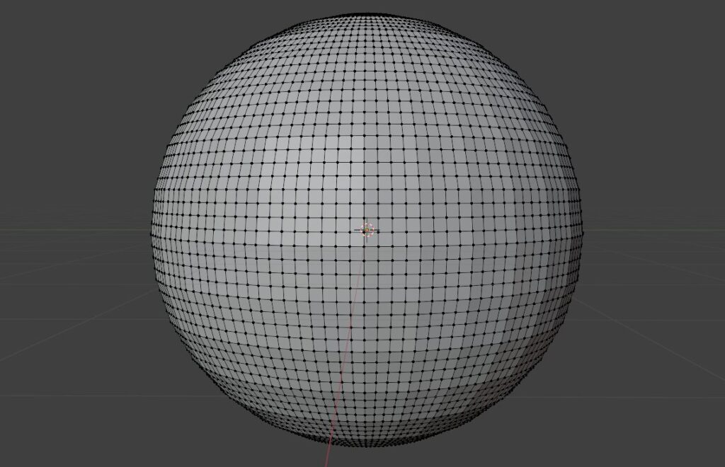
A 3D mesh model represents three-dimensional structures using a network of vertices, edges, and faces. It typically follows this process:
- Point Cloud Generation: Shared features from multiple images are detected and compiled into a point cloud.
- Mesh Construction: These points are connected by lines to form edges, and surfaces (faces) are generated by enclosing those edges.
- Texturing: The final model is wrapped in textures derived from the original photographs, giving it realistic appearance and color.
Advantages: Proven, Compatible, and Editable
Mesh models have stood the test of time due to their versatility:
- Wide Compatibility: Easily imported into most 3D modeling, CAD, and game development software. Mesh models are not bound to any specific platform.
- Easy to Edit: Meshes can be modified using tools like Blender or Maya, making it simple to adjust shapes, delete parts, or merge models.
- Established Workflow: Industries such as construction and surveying have well-developed workflows centered on mesh modeling.
- Abundant Resources: With a long history, tutorials and troubleshooting resources are widely available online and in books.
Limitations: Detail Loss and Heavy Data
Despite their strengths, mesh models face several challenges:
- Limited Detail Reproduction: Thin or complex structures (e.g., tree leaves, fences) may be hard to reproduce accurately. Transparent or reflective surfaces are also problematic.
- High Computational Cost: Generating high-quality meshes can be slow and require powerful hardware.
- Large File Sizes: High-resolution meshes and textures tend to produce very large data files.
What Is 3D Gaussian Splatting?
Introduced in 2023, 3D Gaussian Splatting (3DGS) is a cutting-edge 3D representation technique that has taken the community by storm. It can produce photo-realistic, immersive 3D scenes—almost like looking through a window into real life.
3DGS Uses Thousands of Tiny “Gaussians” to Represent 3D Space
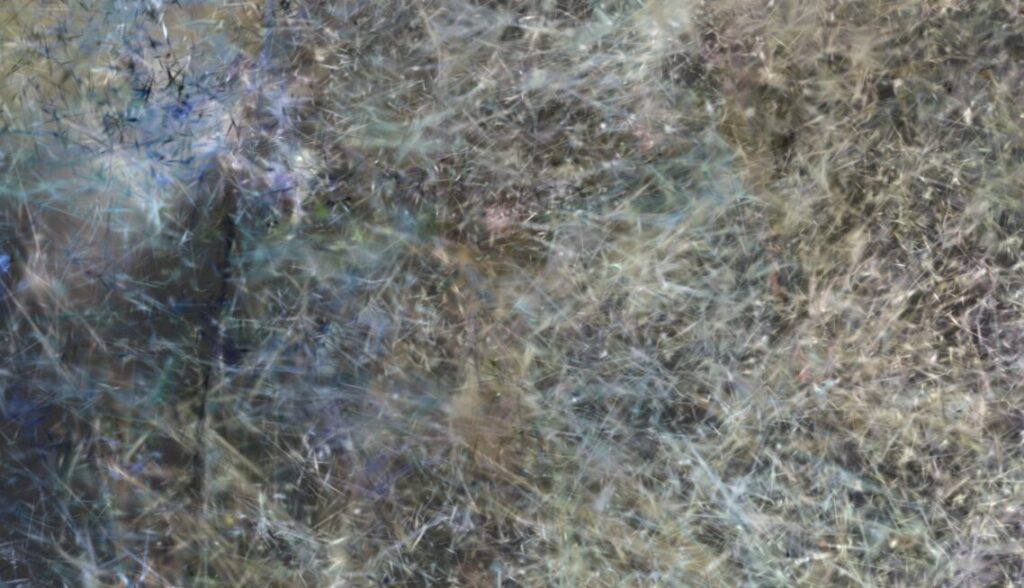
Unlike traditional models that build surfaces from edges and faces, 3DGS uses thousands of soft, semi-transparent ellipsoids (Gaussians) scattered throughout space to represent geometry and texture.
Each point in a point cloud is replaced with a Gaussian primitive, and these are blended together to reconstruct detailed structures, surfaces, and lighting effects without using a traditional mesh.
This allows for realistic rendering of complex reflections, transparency (e.g., glass or water), and organic surfaces like leaves.
Advantages: Unmatched Realism and Speed
Why is 3DGS gaining so much attention?
- Unparalleled Realism: 3DGS captures light behavior, texture, and even semi-transparent elements like fog and water with photo-like accuracy.
- High-Speed Rendering: Once trained, models can be rendered interactively at near real-time speeds—ideal for VR/AR applications and immersive experiences.
- Lightweight Output: Compared to high-resolution mesh models, 3DGS can produce smaller files at similar or even higher visual fidelity.
Limitations: Immature Ecosystem and Editing Constraints
Being a new technology, 3DGS comes with certain challenges:
- Limited Tool Support: Few software platforms currently support it, and usage often requires technical expertise.
- Difficult to Edit: Unlike mesh models, 3DGS is not yet editable in standard 3D software.
- Low Interoperability: While visually powerful, it’s not yet well-suited for use in CAD, BIM, or precise measurement workflows.
Despite these hurdles, rapid development in the field suggests these limitations may diminish in the near future.
Real-World Comparison: Matsumoto Castle in 3D Mesh vs. 3D Gaussian Splatting
To compare the two methods, we created two 3D models of Matsumoto Castle, one of Japan’s National Treasures.
The drone imagery was captured under special permission (Photography supported by: Matsumoto Tourism & Convention Association).
We used ~2,000 aerial images captured with a DJI Matrice 350 RTK equipped with a Zenmuse P1 high-resolution camera.
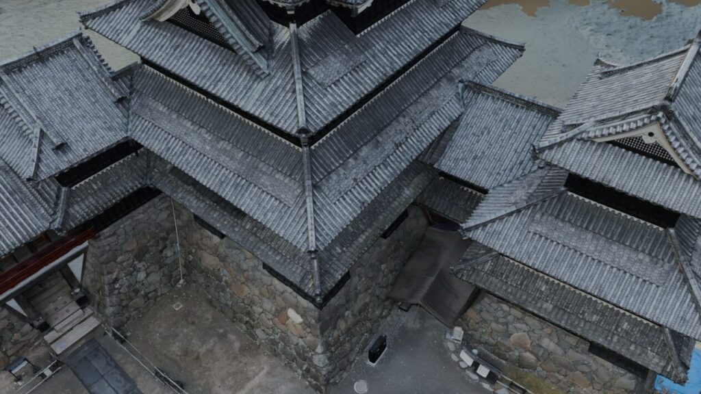
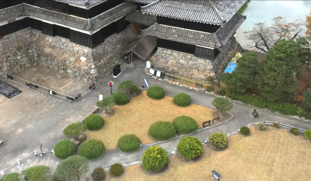
Mesh Model of Matsumoto Castle
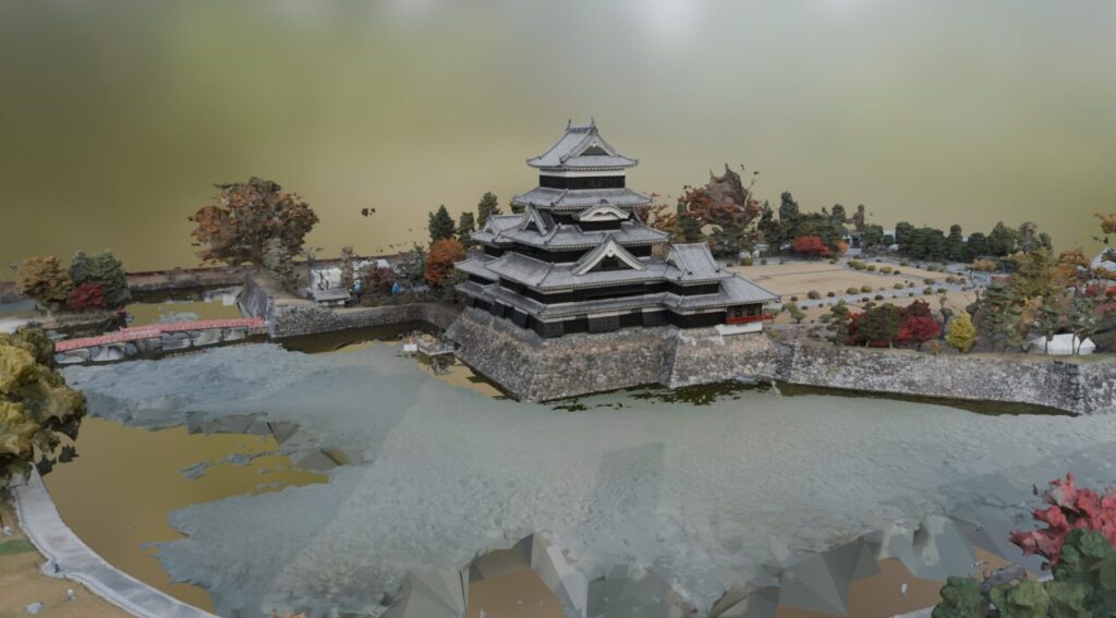
Using the traditional photogrammetry software RealityCapture, we generated a 3D mesh model.
- Water surfaces in the moat were missing, a common drawback in mesh models requiring manual correction.
- Tree foliage and other fine details were not accurately reconstructed.
- However, roof shapes and stone textures were well represented.
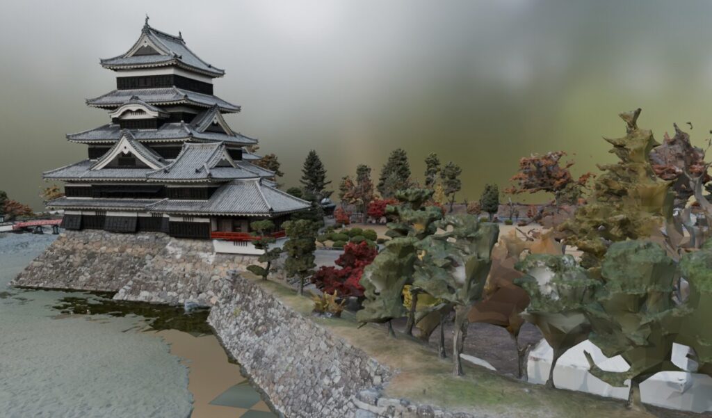
Matsumoto Castle via 3D Gaussian Splatting
Using the same image set, we generated a 3DGS model.
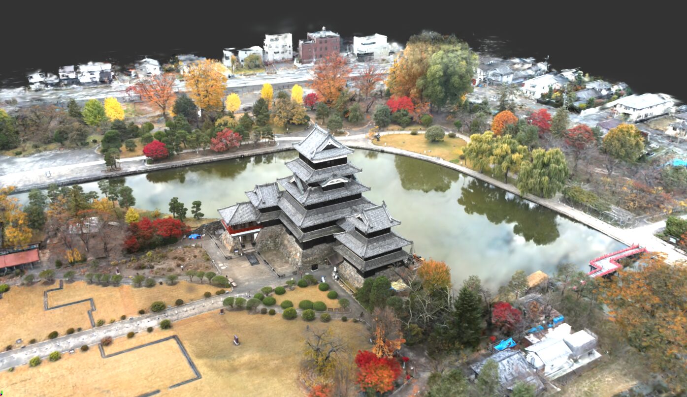
- The water in the moat was clearly rendered, even capturing reflections and transparency.
- Foliage was reproduced with soft, natural textures.
- Overall, the 3DGS version offered a more photo-realistic representation.
Takeaways from the Comparison
This side-by-side comparison of such a complex subject clearly revealed the strengths and weaknesses of both methods:
- 3D mesh models are ideal for general-purpose use, especially where measurement, editing, and CAD/BIM integration are needed.
- 3DGS, while less flexible for technical editing, offers superior visual realism, making it perfect for immersive visualization and digital archiving.
When Should You Choose Each Method?
Choose 3D Mesh Models for:
- Precise surveying and terrain modeling
- Structural inspection and damage documentation (bridges, cultural heritage, etc.)
- Game and film asset creation
- Integration with CAD or BIM workflows
Choose 3DGS for:
- Digital archiving of cultural landmarks (e.g., Matsumoto Castle)
- Recording fine surface detail and materials
- Background generation for games and films
- High-impact, immersive visualizations
Let ASOLAB Handle Your 3D Modeling and Photogrammetry
Our drone division, Sky Fight Matsumoto, based in Matsumoto City, Nagano Prefecture, offers comprehensive drone-based services, including aerial surveys, structural inspections, and high-resolution 3D modeling using both traditional and next-gen technologies like 3DGS.
Why Choose ASOLAB?
- Experienced Team: Our expert drone pilots and technicians tailor solutions to your specific needs.
- Cutting-Edge Capabilities: We actively adopt emerging technologies like 3D Gaussian Splatting, ensuring you get the most advanced modeling methods.
- Local & Nationwide Service: While based in Matsumoto, we support projects across Japan.
Want to explore what drones can do for you?
Curious about the latest in 3D modeling technology?
Looking to preserve an important structure in 3D?
ASOLAB turns your ideas into reality.
Feel free to contact us anytime.